Be wary
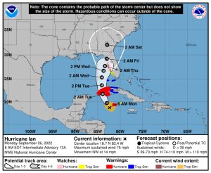
Over the weekend, Tropical Depression 10 leaped past Tropical Depression 9 by a few hours to become Tropical Storm Hermine. Tropical Depression 9 then became Tropical Storm Ian, and has become Hurricane Ian overnight. This system is beginning to affect Cuba, and will likely be a major Hurricane when it crosses the western edge of Cuba overnight. Ian is projected to undergo rapid growth and intensification over the next 48 hours or so as atmospheric conditions are favorable for intensification, and the storm will pass over very warm surface waters. The current forecasts are of interest, but still contain numerous potential errors due to the complicated interactions that will affect strength, path, and timing.
The latest forecast, issued this morning by the National Hurricane Center (www.nhc.noaa.gov), indicates that Ian will soon begin to produce heavy rainfall in Cuba. The system will then be steered to the north-northwest and strengthen dramatically as it encounters favorable atmospheric conditions and very warm Gulf waters. The forecast will become more settled and more precise after the system leaves Cuba and heads into the Gulf of Mexico. The track forecast for Ian has varied a bit since Friday. However, Ian is currently projected to approach the coast of Florida near Tampa, and make landfall around Cedar Key in the early-morning hours Friday. The storm will then weaken as it moves northward through Georgia. However, even a relatively small change in direction could move Ian to a position that affects Sailboat Bay, so we will continue to closely monitor the available information and provide updates until Ian has dissipated. Ian will be a very large system as it churns northward in the Gulf, and the effects will extend many miles from the eye. The current forecast projects Sailboat Bat to possibly experience Tropical Storm force winds by mid-day Thursday, but our peak winds are not expected to reach 50 knots.
The Board urges Owners and residents to pay attention to forecasts over the weekend. If, and that is a huge IF, Ian is projected to impact Sailboat Bay, we will implement the Hurricane Response Plan. SBB owners are reminded that they need a plan to move outdoor furniture inside, secure boats in the marina (and remove canvas!), and ensure objects under our buildings are properly stored and secured 24 hours prior to storm arrival If the Board determines there is significant additional threat, owners will be advised by email and directed to remove ALL vehicles from under buildings. The SportsPlex on County Road 6 is one available option. Golf carts may be moved to the Boat Yard.
We will meet with the Contractors Monday at 9 AM to plan how their work could be impacted by Ian, and where their equipment and supplies should be located and secured to minimize damage to the materials and to Sailboat Bay.
Updates will be posted as information becomes available.